Resources for planning applicants
Planning applicants wishing to undertake development may find the following documents helpful:
- Arup Mapping Report_RevA_Issue 010416_Reduced
- Figure 7 – Results Map (latest version)
- RedFrog Results Database.kmz
- Spring Line + Arup map
- (89) Environment Agency – RedFrog surface water flood risk south
- (89) Environment Agency – RedFrog surface water flood risk north
- Managing Flood Risk in Camden – Consultation
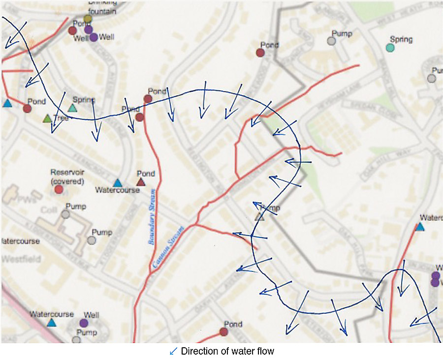
Marking the Direction and Flow of Underground Rivers
This is a prospective project
RedFrog has been interested in daylighting underground rivers, following a meeting with water engineer, Dr. Stephen Myers, in May 2015, and the commissioning of Arup to map underground rivers for the neighbourhood plan evidence base at the end of 2016.
The presence of underground rivers or other bodies of water is often indicated by soggy ground, poplar and willow trees.
The report generated by ARUP is available here:
Arup Mapping Report_RevA_Issue 010416_Reduced
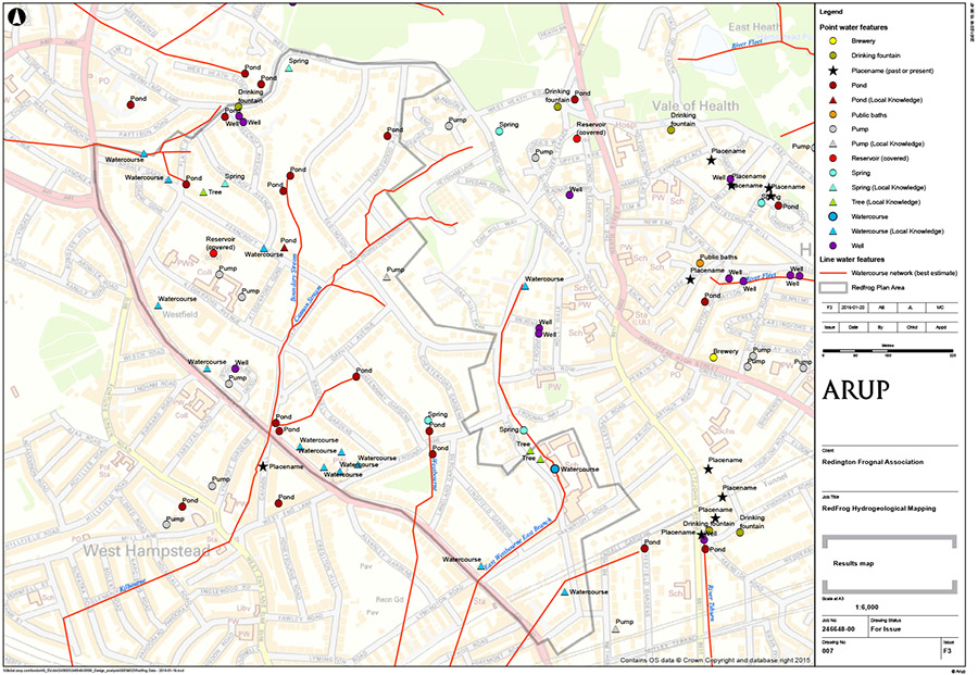
The Arup map of RedFrog underground rivers indicates the presence of many historic rivers, such as the Westbourne, East Westbourne, Cannon, unnamed rivers, springs, wells and ponds. As many as five water courses can be found within a space of 800 yards. While these have mostly been absorbed into sewers, clean water runs between Branch Hill and Redington Gardens, where the stream can be heard. Mostly, however, the streams have become degraded, devalued, and discarded – interred in underground culverts, out of sight, out of mind.
Where possible, it is therefore proposed to increase awareness of these underground streams through “daylighting”, by restoring hidden water to a more natural state above ground, along with the environmental virtues of biodiversity, enjoyable green spaces, and flood prevention.
Where this is not possible, the streams will be culturally daylighted through marking their direction and flow, using cast bronze glyphs. This could form part of a long-term vision to support local history, geography, green space and legibility.
A Watermark trail is being developed by Robin Lacey, a sculptor specialising in bronze for the public realm, and with a particular interest in place. His presentation to the Association is available here: Robin Lacey Talk Notes draft 3
In July 2017, RedFrog was introduced to Robin Lacey and, with the support of Camden, CIL funds were authorised to mark the underground rivers which had been identified by Arup together with citizen science (RedFrog residents).
Arup RedFrog Sub Surface Water Features Map and Spring Line
Underground Water Features
The ground beneath Redington Frognal is a complex layering of Bagshot Sand, Claygate Member and band D of the London Clay Formation. The top two layers have a high silt and sandy component rendering them susceptible to high water conductivity, as well as being potentially less stable.
In parts of Redington Frognal the water table ground water flow is constant and rapid. Basement excavation can sometimes break into continuous flow of these water tables, but will also constrain and divert the ground water present throughout the area, causing erosion of the high silt and sand content of Redington Frognal’s soil types leading to significant volume loss. This results in the frequent subsidence of neighbouring buildings and formation of cavities under roadways and services.
Crater big enough to fit a man in opens up in Hampstead
Ham&High PUBLISHED: 13:18 21 October 2011, By Josh Pettitt
A vast hole in the road leading to an underground chasm opened up in Hampstead over the weekend.
Cllr Chris Knight discovered the apparent pothole in the middle of Redington Road on Saturday afternoon. But it turned out to a small opening leading to a gaping cavern below – sparking renewed fears about the effects of basement developments on Hampstead’s foundations.
The former cabinet member for environment said: “The hole is big enough to swallow a small car. “This is precisely the sort of thing that’s very worrying for people. It does not bode well for basement construction in the area if one small water flow can do this.”
He believes the hole formed because of sand being eroded over a long period of time.
Arup Map of Redington Frognal Underground Rivers
In the wake of growing concerns, ARUP was commissioned to map underground rivers for the neighbourhood plan evidence base at the end of 2016. The research was conducted with the aid of citizen science.
The ARUP report generated is available here:
Arup Mapping Report_RevA_Issue 010416_Reduced
The resultant map with water features identified to date is shown below. This will be updated as new features are discovered:
The latest map from 20-01-2016 is shown below:
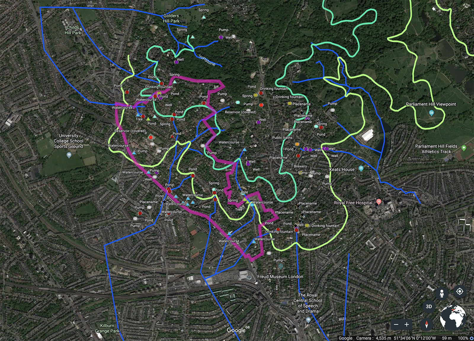
ARUP have also generated an interactive map, which is available online through Google Earth. This online version highlights the water features charted. Within Google Earth you can hide and display any of the listed features, and interact in other ways similar to Google’s more common Maps app. A snapshot of this version is shown below:
Spring Lines
Spring lines typically occur at the junction of the Bagshot Sands and underlying clay units.
The geological complexity of the Redington Frognal area is such that springs may occur at the boundary between:
- Bagshot Formation and Claygate Member
- e Claygate Member and London Clay
- and potentially anywhere in between, depending on the local hydrogeological conditions.
Redington Frognal Spring Line
An updated map showing the spring line is shown below:
This file is also available as as pdf here: Spring Line + Arup map
And a further map of the spring line is attached below:
Source: Drawn for 28 Redington Road Planning Appeal APP/X5210/W/3164577, 12.19.17 by MH de Freitas PhD, DIC, C.Geol, C.WEM, Emeritus Reader in Engineering Geology, Imperial College London and Ground Engineering Adviser, UK Register of Ground Engineering Professionals (RoGEP) (68302453)
Environment Agency: Redington Frognal Flood Risk from Surface Water – southern section
(89) Environment Agency – RedFrog surface water flood risk south
Environment Agency: Redington Frognal Flood Risk from Surface Water – northern section
(89) Environment Agency – RedFrog surface water flood risk north